Practitioner Lecture: Application of Marine and Coastal Environment Mapping
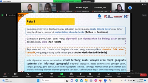
Marine science study program attended the practitioner lecture series on Tuesday, 14 November 2023. This lecture was given by Atikah Kumala Dewi, S.Kel., M.Si., a staff of the Geospatial Information Agency. She discussed the definition of map and mapping, the primary map and thematic map type, and data sources for coastal and marine mapping. Students can identify the primary map, such as coastal line, hypsography, waters, borderline, transportation, building, land cover, and utility, that can be known as an Indonesian topographical map. Understanding the application of marine mapping is important for students to manage the marine environment, explore marine resources, and conduct scientific research. It can be applied to marine resources, coastal line change maps, bathymetry maps, and marine toponymy maps.
In this session, students also learned about the method and data that can extract the coastal and marine phenomena such as remote sensing data, lidar, airborne data, and hydrodynamic modelling. Not only learned about the definition and principles of each method for marine mapping, but also learned about the advantages and disadvantages of each method. Finally, students accessed available online data directly downloaded from each website. It can be used directly to create marine and coastal information maps. This lecture was closed by online documentation, both students and lecturer.